
Visit
Hiking Safely at Karmê Chöling
Enjoy Karmê Chöling’s trails, take in the beauty of the land, and hike with care. Please follow these guidelines to stay safe on Karmê Chöling’s trails.
Before You Leave
- Check the weather forecast and avoid hiking during severe weather.
- Hike with a partner whenever possible.
- Tell someone which trail you are taking and when you expect to return.
- Carry a fully charged phone, but do not rely on it. Cell service is limited and may be unavailable.
- Wear sturdy footwear and weather-appropriate clothing.
- Bring water and any medications you may need.
- Dress in layers and prepare for changing conditions.
- Review the tick-prevention information provided in your welcome packet.
- During hunting season, wear blaze orange. Current hunting dates are posted on the bulletin board and can be confirmed at vtfishandwildlife.com.
Share Your Location with KCL
- Open Google Maps.
- Tap your profile picture, then Location sharing.
- Tap Share location and choose a time longer than your hike.
- Text the sharing link to (802) 633-4747.
Location updates require cell service. Staff may only see your last reported location if service is lost.
On the Trail
- Stay on designated trails and pay attention to markers and landmarks.
- Trail conditions may change because of weather, mud, fallen trees, stream crossings, or seasonal growth.
- Plan to return well before dark.
- Watch for slippery rocks, roots, uneven ground, and other hazards.
- If you are uncertain of the route, stop and retrace your steps to the last place you were certain you were on the trail. Do not continue farther hoping to find it again.
- Ticks are common in Vermont. Wear long pants, consider using insect repellent, and perform a thorough tick check afterward.
- Smoking and open flames are prohibited on the trails.
- Pack out everything you bring in. Do not leave trash, food, or other materials behind.
- If you see a Do Not Enter sign, please respect it. Some areas are reserved for private solo retreats, and we are committed to protecting the retreatants’ privacy and seclusion.
If You Need Assistance
If you are overdue, lost, or unable to return as planned, call Karmê Chöling as soon as possible. Do not wait until dark. Staff familiar with the property and trails may be able to assist more quickly than outside responders.
For a medical emergency, injury, or immediate danger, call 911 first if you have cell service. Then notify Karmê Chöling if possible.
Emergency Number: (802) 633-4747
Before Every Hike
- I know which trail I am taking and have communicated it with someone including when I expect to return. I know what time it gets dark and will be back well before then.
- I have water and any needed medications.
- My phone is charged.
- I have suitable clothing and footwear.
- I have a printed map or an offline map downloaded to my phone.
The Trails
Choose a trail appropriate for your experience, fitness, available daylight, and current conditions.
Naga Trail
Easy
0.4 miles | Allow 15–25 minutes
Short, gently rolling trail with a few moderate inclines.
Tiger Trail
Moderate, steep
2 miles round trip | 630 ft. elevation gain | Allow 1½–2 hours
Mila’s Loop
Moderate
2.1 miles total | Allow 1¼–1¾ hours
Hike 0.38 miles up Tiger Trail to the junction, complete Mila’s Loop, then return down Tiger Trail.
Rigden Ridge Trail
Difficult
3.4-mile route via Tiger Trail | Allow 3–4 hours
Very steep, rugged, and lightly maintained, with approximately 940 ft. of climbing. Some descents may require using your hands or lowering yourself carefully. Not recommended for inexperienced hikers, young children, or wet conditions. Begin at the Tiger Trail parking area and return via Tiger Trail.
Trail Map
Before hiking, open the interactive Google trail map. With cell service and location access enabled, it can show your position on the trails.
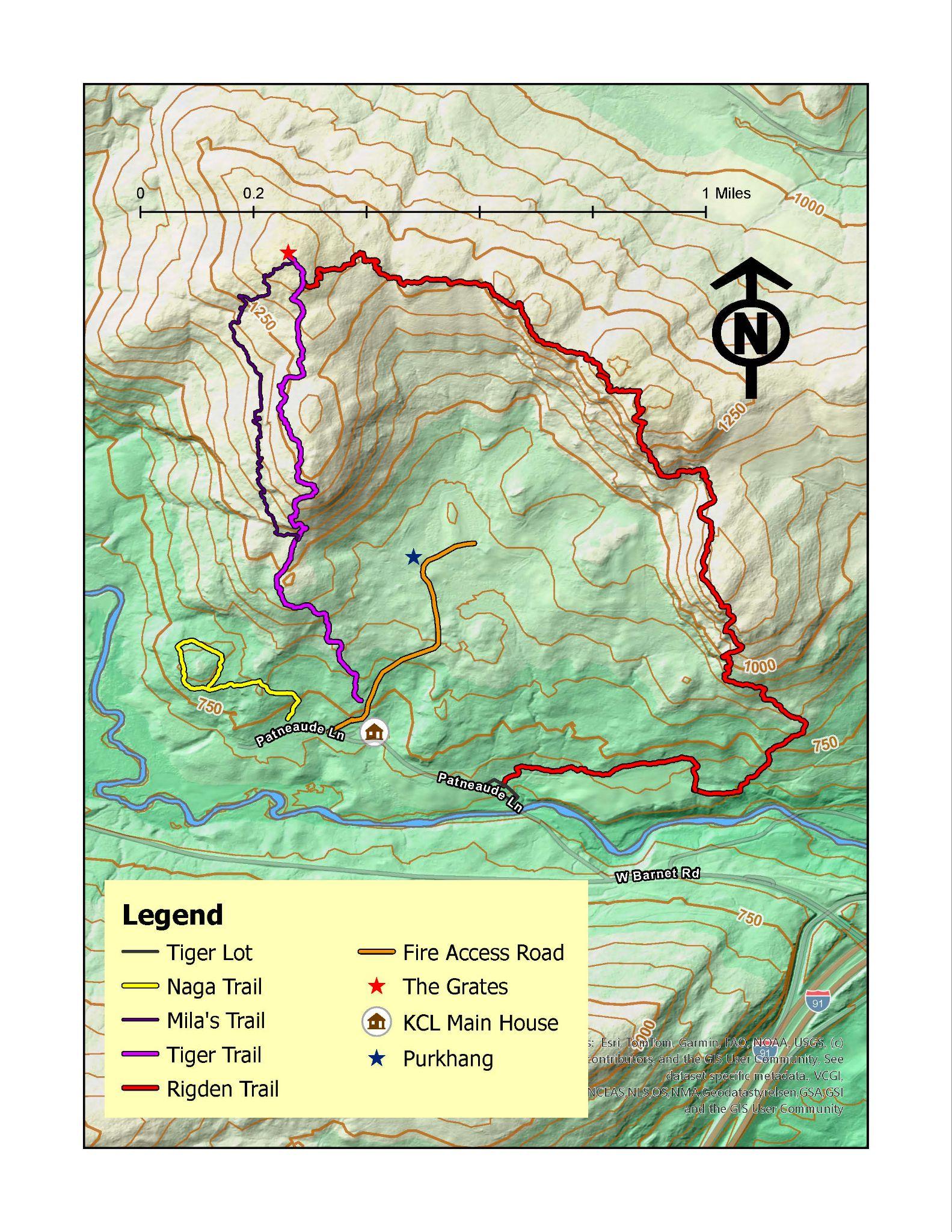
GPS Reference Points
These coordinates identify familiar locations on the property and may help staff or emergency responders understand your location. Coordinates are shown in degrees and decimal minutes.
- Grates: N44° 18.9649' W72° 4.3062'
- Purkhang: N44° 18.5167' W72° 4.1208'
- Main House: N44° 18.2477' W72° 4.2009'